Then … The insurance investigator handling the death of Susan Dumurrier is ready to report back to his superiors. Here he looks up at his office building.
… and Now, he’s on Sansome Street with Pine Street crossing behind him. Today’s matching view 52 years later is the same.
Then … As he walks in, the camera pans up to the building’s name - the Royal Insurance Building at 201 Sansome Street in the Financial District (map).
… and Now, the matching view is unchanged in appearance but the sidewalk clock is gone.
… and Now, the 11 story 1907 landmark office building was converted into 46 luxury condominium units in 2006, renamed The Royal.
The investigator presents photos of Susan and Monica and reports that George has become, shall we say, involved with Monica. Suspecting that they are one and the same woman and that Susan is still alive, they decide to turn the case over to the police.
Then … Monica is picked up for questioning; the patrol car is seen here pulling up to a nearby police station.
… and Now, but this isn’t San Francisco - it’s South San Francisco, a separate city just, well, south of San Francisco. This view looks south along Maple Avenue; the building on the left with the sign is the Caledonian Club of San Francisco at 312 Maple - it’s still there today, with a modified sign.
Then … The detective pushes Monica up the steps to the station. Note the insignia on the side of the police car - SSF Police. This is what led CitySleuth to search in South San Francisco.
… and Now, the building is still there, at 315 Maple Avenue, but is now used by the city as a departmental annex. It was the city’s only police station when the movie was filmed until the PD moved to another building, 33 Arroyo Drive, in 1981. An even newer station at 900 Antoinette Lane is scheduled to be ready by the end of this year.
Then … Looking across the street from the steps there’s another view of the Caledonian Club on the east side of the 300 block of Maple Ave.
… and Now, the railings on the steps have been upgraded and that’s about it.
Inside the station the police investigator assigned to the case, Inspector Wald (Canadian actor John Ireland, on the left), tries to figure out Monica’s role in the mystery.
A search of her apartment uncovers a hieroglyphic-like ink blotter. A hand-writing specialist (director Lucio Fulci in a cameo role) discerns clear evidence of her having practiced writing Susan Dumurrier’s signature.
To help sort out the confusion over the Monica/Susan identities the police decide to exhume the body of Susan Dumurrier. Director Fulci would, with subsequent movies, go on to make a major contribution to the horror movie genre but his only nod in that direction in this movie was this brief shot of the corpse. When Susan’s sister Martha identifies it as Susan and an autopsy determines she died by poisoning the police have George and Monica squarely in their sights in what is now a case of murder.
Then … Mason returns to the room where Moxley was murdered, looking for more clues. This location, at 1850 Sutter Street in Japantown, was described in detail in an earlier post.
… and Now, new buildings were built on the 1800 block of Sutter Street during the Western Addition redevelopment project; the sidewalk tree below is in front of where 1850 Sutter used to be.
He finds a possible clue, a discarded matchbox with a hotel name on the cover.
… in 1938 … These are all of the hotels listed in the 1938 South San Francisco city directory. In the real world there was no Fremont Hotel here.
Then … Mason dispatches Spudsy to follow up on the lead. He finds out that Doris Pender, one of the hotel’s residents, had made a phone call to Moxley the night of his murder. He heads to the Irving Theatre where she is onstage singing.
San Francisco did indeed have an Irving Theatre, listed in the 1935 City Directory at 1342 Irving Street in the Inner Sunset (map). But from the 1941 photo below it’s clear that the marquee doesn’t match the one in the movie; clearly that was a studio creation. The Irving opened in 1926 and closed in 1962, destined for demolition.
… and Now, the building at far left above (back then it housed a Safeway grocery store) is still there today (below), but the theater and the rest of the block to the right were replaced in 1963 by two apartment buildings. The grey building, now re-addressed as 1330 Irving, is where the theatre used to be.
It turns out that the singer had married Moxley a year earlier (so the scoundrel was also a bigamist). After her performance she tells them only that he had been threatening her.
Spudsy tracks down her roughneck brother, Oscar Pender, suspecting that on her behalf he may have tried to get even with Moxley. Pender wasn’t exactly cooperative; his only response was a punch to Spudsy’s jaw.
Maude wants to know what Harold does when he isn't visiting funerals? Cut to a construction site where a wrecking ball is demolishing a building; They watch intently from a balcony across the way.
But where was this filmed? The only skimpy clue that may still be around is that house on the right; CitySleuth has yet to find the location and appeals to his readers for help ...
Then ... They move on to a scrapyard, fascinated by the clattering sounds of recycling at work. In this view from the crane's cab there's a message emblazoned on the hillside in the distance proudly proclaiming 'South San Francisco - The Industrial City'. It enabled this location to be pinpointed.
... and Now, here's that site today, a bare lot next to Exelixis, a genomics company seen on the right at 170 Harbor Way in South San Francisco. This map shows its location with a red marker and, in blue, the hillside sign location, on the aptly named Sign Hill just below Sign Hill Park. If you compare these Then and Now images closely you can match up some of the pylons of the PG&E substation across Gateway Boulevard.
This recently taken aerial photograph gives us a closer look at the Sign Hill slogan. First appearing in 1923, the letters were made permanent in 1929 using gunite, a new material back then, now widely used for forming swimming pools. Cleverly, to compensate for hillside changes in slope, the letter heights vary so that from ground level perspective they appear the same. The city of South San Francisco has morphed over the last century from heavy to light industry, in particular establishing itself as a biotechnology center.
Then ... Back to the scrapyard; this time the camera looks in the opposite direction across Harbor Way.
... and Now, from the same spot today we see a covered bridge crossing Harbor Way, linking two Exelixis buildings.
Then ... But rather than witnessing things being destroyed Maude's preference is watching things grow. In a greenhouse she explains to Harold how the plants represent an affirmation of life - the gospel according to Maude, one might say.
CitySleuth came across an unconfirmed claim that this was filmed at the Avansino-Mortensen Nursery in San Bruno (this map shows where it was). If so, it would have been one of the cluster of greenhouses seen in this c. 1950 aerial photo of the nursery in its prime. Sneath Lane separates the greenhouses from the Golden Gate National Cemetery on the right and across El Camino Real along the bottom that's the Tanforan horse-racing track. Its grandstand is partially visible on the left.
... and Now, two new freeways meeting at the 280/380 interchange now dominate this same aerial view. The nursery served the Bay Area's flower market for 45 years from 1929 until it was dismantled in the 1970s. Tanforan racetrack, opened in 1899, was replaced by a shopping mall in 1971.
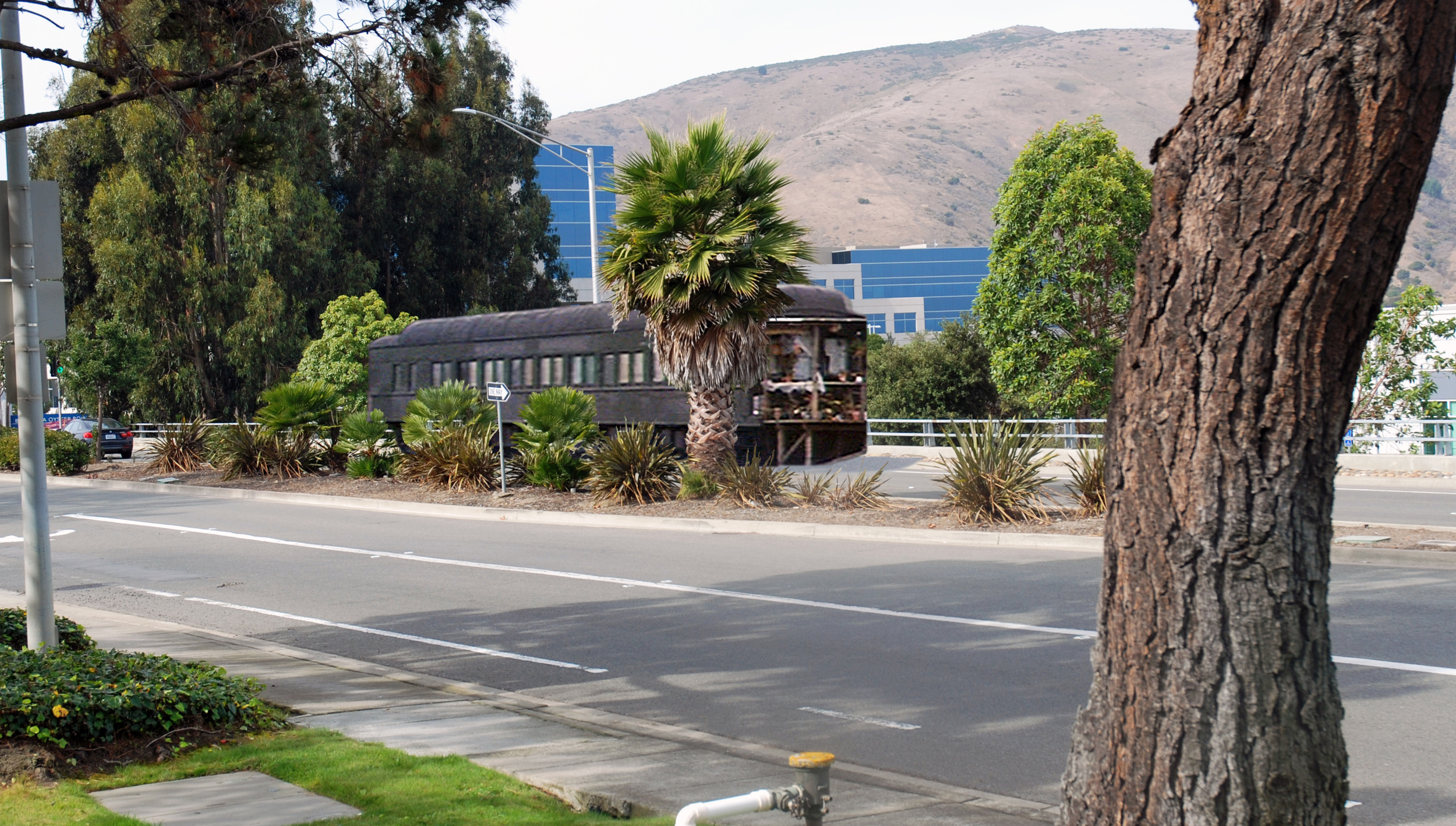
Maude's home is rather unusual, to say the least. She lives in a Pullman railroad car. There were many scenes filmed at the car from which CitySleuth chose examples for this post, revealing the location, and the next post, focusing on the interior.
Here's an undated photo of the railcar used in the movie. Originally built by Pullman in 1913 as a sleeper, it was converted in 1931 to a buffet lounge car and given the number 653. For the next 34 years it saw service with Western Pacific until being retired in 1965 - for a time it was part of the Exposition Flyer that ran between Chicago and Oakland via the Sierra Nevada mountains by way of the Feather River Valley. It was acquired in 1966 by the Western Railway Museum in Solano County, California (map) where it is still on display. The moviemakers leased it from the museum and transported it by rail to the end of a spur line in South San Francisco for the filming.
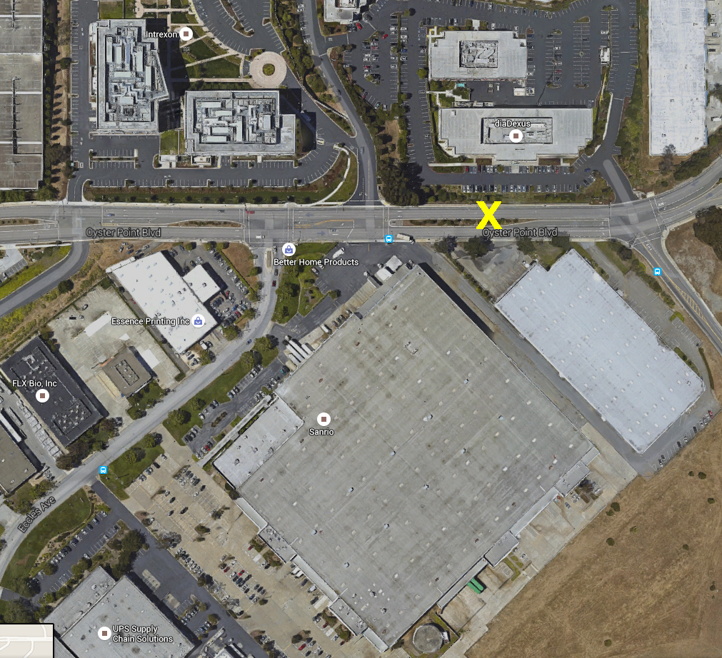
Then ... Harold's hearse-ified Jaguar is parked alongside the railcar on the north side of Oyster Point Boulevard, South San Francisco, between Eccles Avenue and Gull Drive (map). An added covered patio serves as a convenient entry.
... and Now, Oyster Point Boulevard was previously named Butler Road; the roadside spur line was removed when the road was widened into a divided highway and renamed. What if the railcar could be returned to the same spot? ... click to bring it back.
Then ... CitySleuth was able to estimate the railcar site by triangulation from two of the exterior shots. First, as Maude is helped up to the patio we see, across the street, a building which is still there.
... and Now, the same building, viewed from today's median.
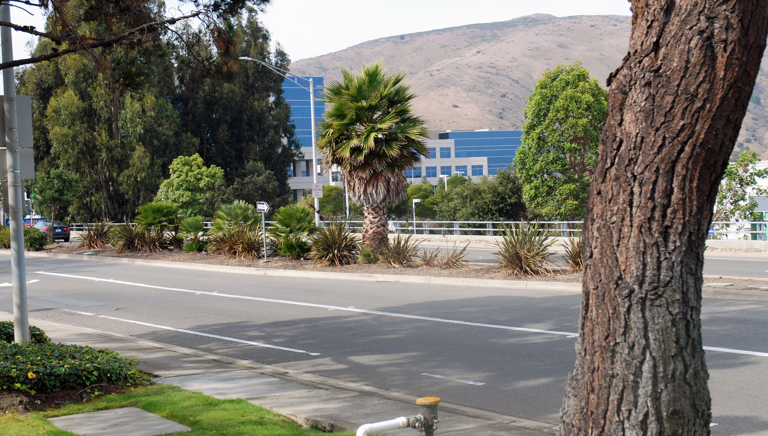
Then ... And second, to the left of that building, across from Maude's mailbox, there's a hydrant and an empty lot.
... and Now, an office building has since been built on the lot but the hydrant is at or very close to the same place, serving as a point of reference.
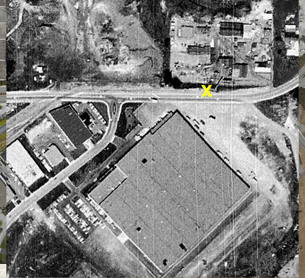
The roadside rail spur is shown on this USGS map: rail tracks and buildings that were there in 1956 are shown in black. Added structures as of 1979 are shown in purple, including both buildings described above across the road from the arrow pointing to where the railcar was.
CitySleuth also created this aerial overlay of Then (a 1968 image) and Now (a Google Earth Image) of the railcar location. Click the image to toggle between 1968 and Now. X marks the spot.
Then ... When Harold drives away from the railcar (it's on the right), the railroad crossing ahead is for the spur line track where it crosses the road as shown on the map above.
... and Now, no tracks cross today so there are no crossing signs - they would have been just past the Eccles Avenue junction. The building at far left across the median is the same as the one above, and new offices - the green building - have since been built next to it.